In order to
ensure a secure means to supply aviation fuel during the operational lifeline
of the Hong Kong International Airport (HKIA), a Permanent Aviation Fuel
Facility (PAFF) is required to replace the existing temporary Aviation Fuel
Receiving Facility adjacent to Sha Chau.
The Airport
Authority Hong Kong (AAHK) is committed to provide the replacement facility and
in accordance with the Environmental Impact Assessment Ordinance (Cap. 499) (EIAO), an Environmental
Permit (EP) is required prior to construction work commencement.
As part of the EIAO requirement, an Environmental Impact Assessment (EIA)
Study including a Marine Archaeological Investigation (MAI) was conducted. The revised EIA was submitted in 2007 and the
environmental permit (EP-262/2007)
was granted in May 2007. EP-262/2007 has been amended to EP-262/2007/A and issued by the EPD on
30 November 2007.
It should be
noted that at the time of reporting, a further Variation to the Environmental
Permit has been approved, primarily to allow for dredging works to continue
during March 2008. As such, EP-262/2007/A has been amended to EP-262/2007/B and issued by the EPD on
27 February 2008.
In accordance
with Clause 3.2 of the EP, a marine
archaeologist shall be engaged during the carrying out of dredging works within
25m of the positions SS1 or SS2 to provide recommendations on the dredging
works to avoid any marine archaeological impact.
During
the EIA stage for PAFF, a MAI was conducted and found the area of the proposed submarine pipeline
route to have marine archaeological potential and containing 26 surface and 10
sub-surface anomalies of marine archaeological interest.
In November 2002,
dive inspections were carried out on the 26 surface anomalies and it was
concluded that they were not ‘relics’ as defined under the Antiquities and Monuments Ordinance being composed of various
amounts of recently dumped urban waste, basalt and granite rock and of no cultural
heritage significance. No inspections
were implemented on the 10 sub-surface anomalies and it was assessed that only
anomalies SS1 and SS2 represented potential archaeological material, the others
being located in areas that have been dredged for navigation.
It was recommended in Section 9.8 of the EIA report
and Section 9.2 of the EM&A that a marine archaeological
watching brief be instigated during dredging within 25m either side SS1 and SS2
and a dive survey be undertaken in the nominated area SS1 after 3m of sediment removal and after 1m for SS2 to
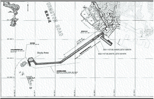
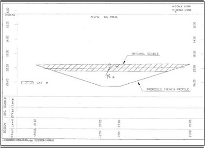
examine the trench for possible cultural remains (see Figure 1.1).
Figure 1.1 Location
of the PAFF Submarine Pipelines Route and
Anomalies SS1 and SS2
This report
presents the marine archaeological watching brief findings and recommendation
made in case marine archaeological deposits are identified.
Following this introductory section, the remainder of this report
comprises the following sections:
Section 2 describes the legislations and
guidelines associated with the works;
Section 3 describes the objectives and methodology for
the watching brief;
Section 4 presents the
watching brief findings;
Section 5 presents
the conclusions;
Section 6 presents
the recommendations; and
Section 7 presents
the bibliography.
The EIAO - TM
outlines the approaches required in investigating and assessing the impacts on
marine archaeological sites. The
following sections of the EIAO – TM are applicable:
Annex 19: “There is no quantitative standard in
deciding the relative importance of these sites, but in general, sites of
unique archaeological, historical or architectural value will be considered as
highly significant. A baseline study
shall be conducted: (a) to compile a comprehensive inventory of places,
buildings, sites and structures of architectural, archaeological and historical
value within the proposed project area; and (b) to identify possible threats
of, and their physical extent, destruction in whole or in part of sites of
cultural heritage arising from the proposed project.”
The EIAO – TM
also outlines the criteria for assessment of impact on sites of cultural
heritage significance as follows:
Annex 10: “The criteria
for evaluating impact on sites of cultural heritage includes: (a) The general
presumption in favour of the protection and conservation of all sites of
cultural heritage because they provide an essential, finite and irreplaceable
link between the past and the future and are points of reference and identity
for culture and tradition; (b)
Adverse impacts on sites of cultural heritage shall be kept to the absolute
minimum.”
The EIAO – TM
also outlines the approach in regard to the preservation in totality, and in
part, to cultural resources:
Annex
19: “Preservation in totality will be a beneficial impact and will enhance the
cultural and socio-economical environment if suitable measures to integrate the
sites of cultural heritage into the proposed project are carried out. If due to site constraints and other factors,
only preservation in part is possible, this must be fully justified with
alternative proposals or layout designs, which confirm the impracticability of
total preservation.”
The Antiquities and Monuments Ordinance (Cap.
53) (AM Ordinance) provides
statutory protection against the threat of development on Declared Monuments,
historical buildings and archaeological sites to enable their preservation for
posterity. The AM Ordinance also establishes the statutory procedures to be
followed in making such a declaration.
“This Ordinance provides for the preservation of
objects of historical, archaeological and palaeontological
interest…”
The Ordinance defines an antiquity as a relic (a movable object made
before 1800) and a place, building, site or structure erected, formed or built
by human agency before the year 1800. The Ordinance also states, amongst other things, that the
discovery of an antiquity shall be reported to the Authority (Secretary for
Home Affairs); that ownership of all relics discovered after 1976 shall be
vested in the Government; that the Authority can declare a place, building,
site or structure to be a monument, historical building or archaeological or palaeontological site or structure (and therefore
introducing certain additional controls for these sites); and that licences and
permits can be granted for excavation and for other work.
Over the years,
surveys have been undertaken to identify archaeological sites in Hong Kong. The AMO has established boundaries for the
identified sites and a set of administrative procedures for the protection of
the known archaeological sites. However,
the present record of archaeological sites is known to be incomplete as many
areas have not yet been surveyed. There
is a need therefore to ensure that the procedures and mechanisms which enable
the preservation or formal notification of previously unknown archaeological
resources that may be revealed or discovered during project assessment or
construction are identified and implemented at an early stage of the planning
of a project.
Section 11 of the AM
Ordinance requires any person who discovers an antiquity, or supposed
antiquity, to report the discovery to the Antiquities Authority.
The MAI
guidelines outline the standard practice, procedures and methodology which must
be undertaken in determining the marine archaeological potential, presence of
archaeological artefacts and defining suitable mitigation measures.
The baseline review,
geophysical survey and establishing archaeological potential are considered the
first three stages of a MAI and this was completed during the EIA stage for the
PAFF in November 2002. Further stages of
the MAI process include one or more of the following, a visual diver survey, a
remote operated vehicle (ROV) survey and a watching brief.
Visual diver
surveys were initiated in the PAFF in November 2002 and while the majority of
the 26 surface and 10 sub-surface sites were concluded not to be of cultural
heritage significance, the nature and significance of two sub-surface sites
(SS1 and SS2) could not be determined. A
watching brief was therefore recommended for these sites.
The objective of
this watching brief is to keep a watch for any archaeological material of
cultural heritage significance when dredging was being implemented through the
seabed to the level of SS1 (three metres) and SS2 (one metre) and within 25
metres horizontally of the anomalies (see Table
3.1). Following the dredging a dive inspection was required to further
assess the seabed for archaeological material.
If any archaeological material was found, an evaluation of impact was to
be made in accordance with the Antiquities
and Monuments Ordnance (Cap 53)
and the Environmental Impact Assessment
Ordnance Technical Memorandum (EIAO-TM) Annexes
10 and 19.
Table 3.1 Detailed Information of SS1 and SS2
|
Target
|
Approximate Depth
|
Depth below sea bed (m)
|
Length (m)
|
Height (m)
|
Latitude
|
Longitude
|
|
SS1
|
19
|
2.5
|
30
|
4
|
22°21.9263’N
|
113°55.3930’E
|
|
SS2
|
21
|
1
|
18
|
2.5
|
22°21.8318’N
|
113°55.2557’E
|
Pursuant to the Antiquities and Monuments Ordinance an
application for a Licence to Excavate and
Search for Antiquities was submitted on 30 November 2007 and granted to the
qualified marine archaeologist, William Jeffery, on 4 January 2008.
On 18 February
2008, a meeting was held with representatives of Leighton Contractors (Asia)
Ltd.(Construction Contractor), UDL Dredging Ltd. (Dredging Works Contractor),
BEKK Solutions Ltd. (Diving Survey Contractor), Ms Peggy Wong (ERM) and William
Jeffery regarding the schedule of dredge watching and the dive surveys taken
into account sea condition and tidal changes.
The watching of the dredging was implemented on 21, 22, 23, 25 and 26
February 2008; and the dive inspections were initiated on 25 and 28 February
2008, all under the supervision or with the attendance of the marine
archaeologist, William Jeffery.
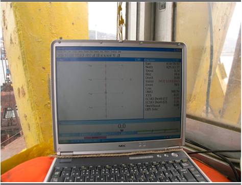
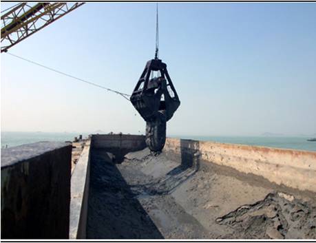
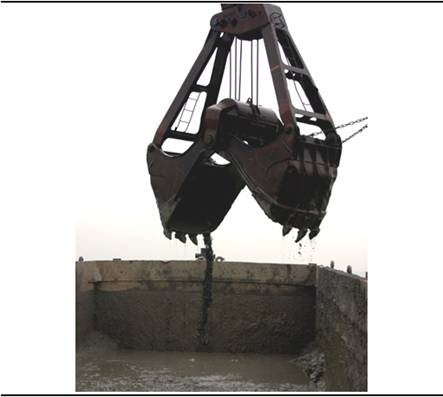
3.2.1
Dredging
A bucket or grab
dredge, capable of dredging a 20-metre wide trench was used to remove seabed
sediments to the level of the sub-surface anomalies (see Figure 3.1). Located at the top
of the crane used to raise and lower the bucket is a DGPS aerial which is
directly above the dredge bucket; the readout is in the cabin with the dredge
operator. This allows for accurate
positioning of the trench (see Figure 3.2).
The computer program displaying the DGPS
coordinates also displays the position of the bucket when dredging the seabed
and provides an offset value to the centreline of the trench. The cables that are used to lower and raise
the dredge bucket are marked every metre to assist the operator in achieving
the correct depth of penetration into the seabed of the bucket.
Figure 3.1 The
Bucket Dredge
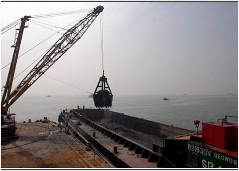
Figure 3.2 The
DGPS Readout as seen by the Dredge Operator
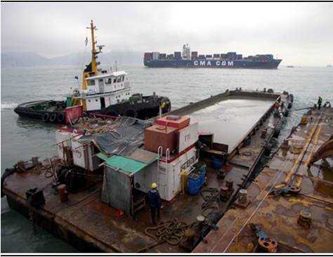
The dredging barge is fixed in position by four large
anchors. It is positioned at one end of
the trench to be dug and winches onboard move it forward along the anchor wires
at 2-3 metre increments. The dredged
sediments (the bucket used in this case had a capacity of 6.5 m3 and
weighs 12 ton) are deposited in a split hopper barge positioned next to the
dredging barge, of which the capacity is about 700m3. The split hopper barge is towed by a tug to
the designated mud disposal areas for uncontaminated and contaminated mud
(south of Cheung Chau/east of Ninepin and East Sha
Chau respectively). (see Figure 3.3).
Figure 3.3 The
Split Hopper
Barge and Tug Boat
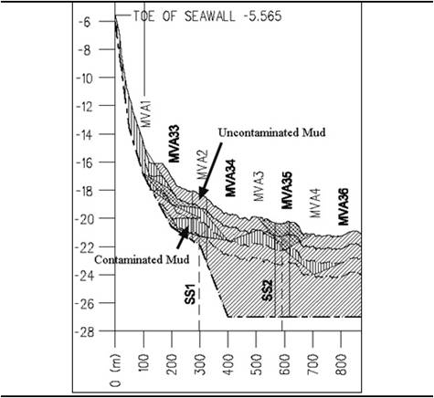
The seabed area
to be impacted by the dredging in the vicinity of SS1 and SS2 varied in
accordance with the planned depths of the East/West running pipelines. At SS1, the depth of the pipelines is to be
about 3.6m. To achieve this depth with
the most appropriate gradient on the trench walls, an area of about 13m to the
north and 13m to the south of the anomaly needed to be dredged (see Figure 3.4).
It was found SS1 is located in an area of
contaminated marine sediments starting at about one metre below the seabed:
this first metre being uncontaminated sediments (see Figure 3.5). This one metre
of sediments was removed by the dredging contractor on 19 February 2008 to
allow for the MAI monitoring/watching of the one, 20-metre wide, two metre deep
trench, 25 metres either side of SS1. This
area was between 275 metres and 325 metres from the seawall at the Tuen Mun Area 38 and amounted to
2,000 m3 of sediment (see Figure
3.5). It takes about 4 hours to fill
the split hopper barge; the total dredging time was computed to be about 12
hours.
Figure 3.4 Cross
Section of the Trench at SS1
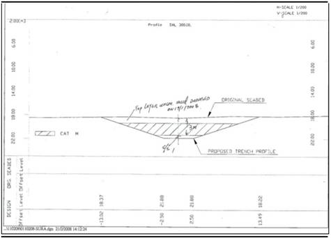
Figure 3.5 Longitudinal
Section Showing SS1 and SS2
At SS2, the planned depth of the pipelines is to be
about 6 metres and providing for the most appropriate gradient of the trench
walls, the area to be dredged is about 20 metres to the north and 20 metres to
the south of SS2 (see Figure 3.6). Two, 20-metre wide trenches were therefore
required to be dredged to the depth of the anomaly of one metre. This area was between 565 metres and 615
metres from the seawall at the Tuen Mun Area 38 and amounted to 2,000 m3 of sediment
(see Figure 3.5). It was computed that the dredging would take
about 12 hours to dredge and dump these sediments.
Figure 3.6 Cross
Section of the Trench at SS2
All personnel
working on the dredging barge were made aware that a watch was being carried
out for any archaeological material. In
particular, the operators of the dredge bucket were made aware that they might
encounter archaeological material and that they might have to stop the
operation for an assessment of any recovered material.
In discussion
with the Dredging Supervisor, it was concluded that the dredge operators would
most likely not ‘feel or hear’ fragile material such as timber when grabbing
the sediments with the bucket and only hard and dense material may be
discerned. This meant that material had
to be grabbed and brought up to be dumped in the split hopper barge for any
archaeological assessment to be made. The
process of dumping sediments in the barge also meant that heavy material would
quickly sink to the bottom of the barge (about 4 metres deep), with a possibility
that more positive buoyant material (timber) may initial remain on the top of
the sediments (see Figure 3.7). Waterlogged
timber from a shipwreck for instance would, however, most likely sink or be
quickly covered with sediment.
Figure 3.7 Dredge
Bucket Dropping Sediment into the Barge
The process of a watching
brief for this project did not rely on the dredge operator on the observation
of the timber in amongst sediment being grabbed on the seabed. Instead, every bucket grab of sediment were
brought to the surface and watched by the marine archaeologist when dumped, and
hence the barge was regularly inspected. If a closer inspection of material sitting on
top of the sediment was required, it was possible to retrieve it from the
barge. This watching was undertaken in accordance with the works programme of
dredging operation, which was a 24-hour operation.
3.2.2
Dive Survey
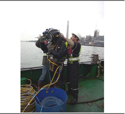
Following the watching of dredging operation, diver inspections of the
exposed seabed were carried out. An
appropriate area in the trench, centred on the anomaly was inspected by a
commercial diver experienced with the local conditions, ie.
nil visibility and strong currents.
The diver wore a full Kirby Morgan full-face mask which allowed
for communications to the surface dive supervisor and the marine archaeologist
(see Figure 3.8). A Bowtech BP-CVIS II compact video inspection
system, incorporating a video camera and light mounted onto the diver’s helmet,
with a hard wire to a surface monitor for real-time display to the surface
operator and marine archaeologist, was also utilised.
Figure 3.8 Diver
Being Prepared for Diving with the Full-face Mask and the Attached Camera and
Lights
A vertical line from the dredge barge to the anomaly was established
(using the DGPS system on the dredge and verified as to the position by the
marine archaeologist) which provided the diver with a commencement point for
his survey. Measured lines were laid out
from this point which the diver used as a guide in surveying the seabed. The diver felt for any objects on the surface
as well as implementing two-three metre probing into the sediment.
The diver was supported on the surface with the following personnel, a
Dive Supervisor, Safety Diver, Attendant and video operator. United States Navy Dive Tables were used and
the non-decompression dive time for 27 metres (90 feet) being 30 minutes, was
used as the bottom time for the diver. Two
divers surveying different sections of the seabed were employed and this
allowed for sufficient time to implement the required survey. The marine archaeologist attended all the
diving and asked the divers to provide comments on what they found during and
after their diving.
4.1.1
Anomaly
SS1
Dredging commenced in the designated area around SS1 at 11:00hr on
Thursday 21 February 2008 and was completed at 09:30hr on Friday 22 February
2008, a total time of 22.5 hours. While
it was estimated that the dredging could be completed in 12 hours, there were a
number of delays due to mechanical factors which contributed to it being
carried out over this extended period.
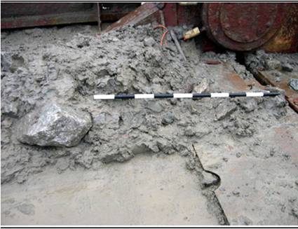
The material dredged consisted of the clayey, silt and mud sediments
consistent with the marine sediments of the Hang Hau Formations. As the dredge approached the location of SS1,
some small granite rocks and a vehicle tyre were recovered (see Figures 4.1 and 4.2). At the exact location
of SS1, some larger granite rocks (c. 500kgm) and fishing netting were observed
as being recovered and dumped into the barge. Apart from a modern bottle, no other material
was found.
Figure 4.1 Vehicle
Tyre in the
Dredge
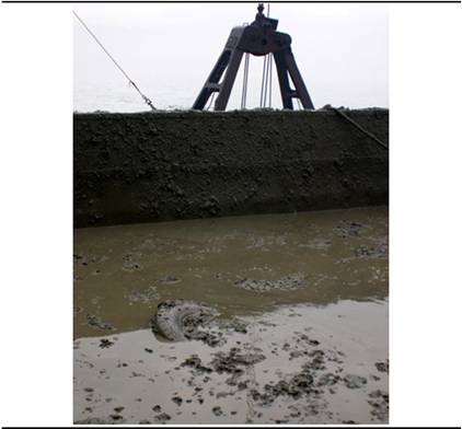
Figure 4.2 Granite
Rocks and Mud, Scale 10cm Divisions
4.1.2
Anomaly
SS2
Dredging commenced in the designated area around SS2 at 11:00hr on
Saturday 23 February 2008 and was implemented until 08:00hr on Sunday 24
February 2008 with still a 40 metre x 20 metre section of dredging to be
carried out. Dredging recommenced on
Monday 25 February 2008 at 13:30hr and was completed by 24:00hr on 25 February
2008, a total time of 31.5 hours. There were mechanical problems in addition to
the strong current and poor weather that contributed to this extended period.
Again, the material dredged consisted of the clayey, silt and mud
sediments consistent with the marine sediments of the Hang Hau Formations. As the dredge approached the location of SS2
(5-7 metres away), and at SS2, some very small amounts of refuse were recovered
(plastic sheeting), in addition to a vehicle tyre, small pieces of wire cable,
a few granite rocks and a fishing net (see Figure
4.3). No other material was found.
Figure 4.3 A
Fishing Net Hanging from the Bucket
5.2 Dive
Survey
The diver
inspection of the seabed (at 22 metres) around SS1 commenced at 11:15hr on 25
February 2008 and was completed by 12:15hr. A line was laid out 25 metres from the
location of the anomaly in a westerly direction for the first dive, and in an
easterly direction for the second dive. The
diver moved along this line feeling for any objects and probing two metres into
the seabed across the 5 metre width of the trench.
A three metre
scattering of small granite rocks were encountered during the first dive. During the second dive, a random scatter of
small granite rocks was encountered; one was recovered for photography (see Figure 4.4). No other material was found. The divers reported nil visibility although
the underwater camera with the aid of a light allowed an occasional glimpse of
the seabed to be seen from about 30 cm away. No objects in addition to what the diver
reported were observed on the video.
The diver
inspection of the seabed (at 22.5 metres) around SS2 commenced at 12:07hr on 28
February 2008 and was completed by 13:17hr. A 25 metre line was laid out from the vertical
line/anomaly in a westerly direction and the diver moved along it searching and
probing over a 5-metre swath of the seabed. When the diver reached the end of the line, he
moved north 15 metres and implemented another search and probing survey back to
the start point. No objects of any kind
were encountered.
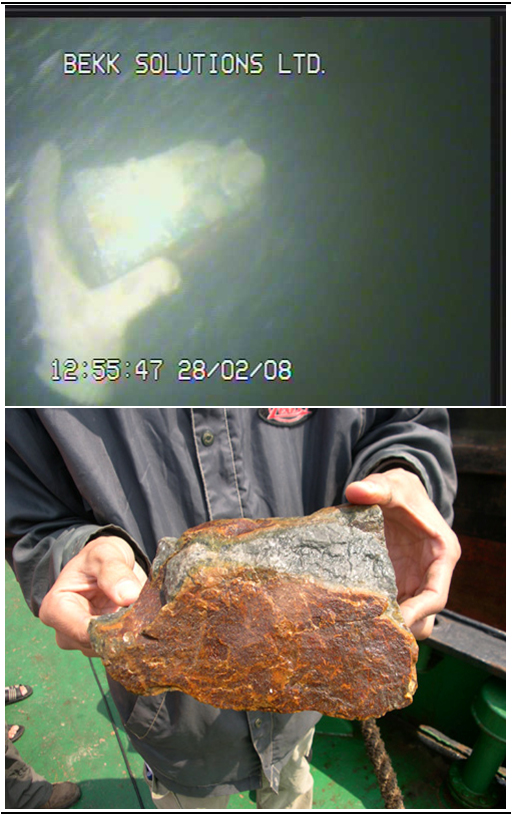
During the second
dive, a swath of seabed 25 metres east x 20 north/south of the anomaly was
surveyed. A few shells and 2-3 small
feldspar rocks were observed through the underwater video, one was recovered
for photography (see Figures 4.5). While the divers reported nil visibility, the
camera provided for a reasonable picture of the seabed from 30cm above and
clearer to that observed in SS1. No
objects in addition to what the diver reported were observed on the video.
Figure 4.4 Small
Granite Rock from SS1
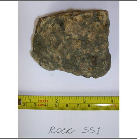
Figure 4.5 Diver
Holding Feldspar Rock at SS2 and a Small Feldspar Rock from SS2
5
Conclusions
The material
observed during the dredging and dive surveys in the vicinity of the SS1 and
SS2 anomalies has no cultural heritage significance. No archaeological material was observed during
the dredging in either area. What was observed included a small number of
rocks, fishing nets and vehicle tyres. The
diver surveys, conducted at the depths that exposed the anomalies, failed to
locate any material other than a small number of granite and feldspar rocks. These same rocks can be found as land fill in the
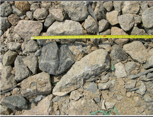
yard with the PAFF tanks (see Figure 5.1)
Figure 5.1 Rocks
Similar to that Found at SS1 and SS2 in the Current Landfill adjacent to the
PAFF Fuel Tanks
It is concluded
that the anomalies are associated with the contemporary use of Urmston Road as a
busy seaway and the activities of the adjacent factories, power station, PAFF and reclamation material collection area.
No mitigation
measures need to be put in place by the PAFF project in regard to the anomalies
SS1 and SS2 are of no cultural heritage significance.
This Watching
Brief was implemented in accordance with the current Marine Archaeology Impact
process, which calls for:
- Baseline Review
- Geophysical Survey
- Establishing Archaeological Potential
- Remote Operated Vehicle (ROV)/Visual
Diver Survey/Watching Brief
Tasks 1 and 2 are
analysed and synthesised to establish the archaeological potential (Task 3) of
an area and sites. If an area or sites
have archaeological potential then Task 4 can be recommended and where, as in
this case, a diver survey is not conclusive in regard to assessing the
archaeological potential of two anomalies, then a Watching Brief during
dredging can be implemented. Dredging is a destructive process to
archaeological sites such as shipwrecks which can contain timber and a whole
range of fragile organic and non organic material. It is also destroys the provenance of
artefacts which is fundamental in analysing archaeological material. The MAI process and particular the Watching
Brief is an attempt at an equable and practical solution in mitigating the
impact of construction activities on archaeological material while providing
for a project’s continuance.
Coroneos, C.,
2004, Permanent Aviation Fuel Facility
Area 38 to Sha Chau, Pipeline Route and Berthing Facilities.
Marine Archaeological Investigation, Task 3 Assessment of Archaeological
Potential. Archaeo-Environments Ltd.